- Gratis verzending vanaf 30 euro
- Levert in Nederland, België etc.
- Meer dan 30.000 titels
- Vakkundige klantenservice
- Snelle levering
- Veilig en eenvoudig betalen

Direct contact?
Bel +31 (0)6 42428571
maandag t/m vrijdag
van 10 tot 17 uur
Fietsgids the Lancashire Cycleway | Cicerone
The tour and 17 day rides

Comprising two distinct loops that intersect at Whalley in the Ribble Valley, the 425km (265 mile) Lancashire Cycleway showcases the idyllic scenery of England's historic Red Rose County. The Northern Loop contrasts the quiet lanes and peaceful countryside of northwestern Lancashire with the thrill of the open moors of the Forest of Bowland AONB; the Southern weaves its way between the villages and towns in the south of the county, an area rich in social history. Easily accessible from the region's rail network, the route – which is all on-road – can be cycled either as a tour or a series of day rides. This guidebook presents the Lancashire Cycleway in 11 stages of 26.6-49.7km (16.5-30.9 miles), plus two short connections to link the loops to the major regional stations at Lancaster and Wigan, as well as 17 varied day rides for those wishing to explore the county further. Detailed route description and 1:100,000 mapping is presented alongside a wealth of information on local points of interest and facilities, and the magnificent colour photography offers a small taste of what the routes have to offer. The guide also includes useful advice for those new to cycling or cycle touring. Lancashire is a great place to cycle, and cycling is a great way to see Lancashire. One of its delights is its sheer variety. There's easy riding on the flat expanses of the west of the county and the gentle undulations of Arnside and Silverdale or the Ribble Valley. More stirring challenges are found in West Pennine Moors and the epic crossing of the Bowland Fells. But even on the wildest stretches, you're never too far from a welcoming pub and somewhere to sleep. Activities
Cycling, cycle-touring, day rides Seasons
Year-round possibilities, although poor weather in winter is to be avoided. Centres
Whalley, Clitheroe, Burnley, Wigan, Preston, Lancaster, Blackpool, Lytham St Anne's and Kendal are all within easy reach or on the route. Difficulty
Easy through to fairly challenging. All within the range of a moderately fit cyclist. Access by rail at numerous points means that less experienced cyclists can do it in shorter sections. Must See
Crossing the Forest of Bowland, exploring the villages of western Lancashire.
Engelstalig
EAN: 9781852848491
Uitgeverij: Cicerone Press
Verschijningsdatum: 2017
Meest recente editie
Engelstalig

(Tijdelijk) niet leverbaar
- Vakkundige klantenservice
- Groot assortiment
- Gratis retourneren binnen 14 dagen
- Aangesloten bij WebwinkelKEUR
Meer producten die interessant kunnen zijn
Topografische kaarten Midden-Engeland
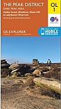
Topografische Wandelkaart OL1 van Groot-Brittannië (1:25.000) Peak District - Dark Peak area - Explorer Map OL 1
Wandelkaart | Ordnance Survey (OS) Groot-Brittannië
€ 18,99
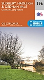
Topografische Wandelkaart 196 Sudbury / Hadleigh / Dedham Vale Lavenham & Long Melford - Explorer Map
Wandelkaart & Fietskaart | Ordnance Survey (OS) Groot-Brittannië
€ 18,99
Topografische Wandelkaart 205 Stratford-upon-Avon / Evesham Alcester - Explorer Map
Wandelkaart & Fietskaart | Ordnance Survey (OS) Groot-Brittannië
€ 18,99

Topografische Wandelkaart 211 Bury St Edmunds / Stowmarket Debenham & Elmswell - Explorer Map
Wandelkaart & Fietskaart | Ordnance Survey (OS) Groot-Brittannië
€ 18,99
Tijdelijk niet leverbaar
Wandelgidsen Midden-Engeland
Wandelgids 74 Malverns to Warwickshire Pathfinder Guide
Pathfinder Guide 01 | Met Ordanance Survey kaarten
€ 17,95
Tijdelijk niet leverbaar

Reisgidsen Midden-Engeland
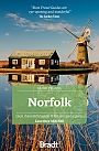
Reisgids Slow Norfolk Bradt Travel Guide
Local, Characterful Guides To Britain's Special Places
€ 21,50
Wegenkaarten Midden-Engeland
Fietskaarten Midden-Engeland