- Gratis verzending vanaf 30 euro
- Levert in Nederland, België etc.
- Meer dan 30.000 titels
- Vakkundige klantenservice
- Snelle levering
- Veilig en eenvoudig betalen

Direct contact?
Bel +31 (0)6 42428571
maandag t/m vrijdag
van 10 tot 17 uur
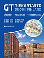
Wegenkaart - landkaart Finland | ITMB
Water- en scheurvaste wegenkaart

De ITMB kaarten kenmerken zich door een kleurrijke en volle cartografische weergave. Het zijn degelijke kaarten, zeker voor gebieden waarvoor kaarten lastig te krijgen zijn, met aanduidingen van onder andere nationale parken en natuurgebieden, vliegvelden, toeristische bezienswaardigheden en een goede aanduiding van het wegennet. Daarnaast bevatten enkele kaarten ook stadsplattegronden (hoofdsteden of belangrijke centra). Bevat voor sommige landen ook aanduidingen in de orginele taal. Water- en scheurvaste wegenkaart. It brings this interesting title for yet another European travel destination into the ITMB style of mapping, with attention to points of interest as well as considerable detail for roads, towns, and physical features. The southern half of the country is on one side, along with two large inset maps of Helsinki and region. The network of roads and lakes on this side is fascinating. The other side concentrates on the northern portions, with a certain amount of overlap into Sweden and Norway. Border information with Russia is also noted, but it is not advisable to travel too close to the border. The map is printed on waterproof paper for durability. Roads by classification, Railways, Airports, Roads closed in winter, Lakes, Glaciers, Tidal Flat, Museums, Unesco World heritage, Castle and much more.
Schaal: 1:750.000
Engelstalig
EAN: 9781771292825
Uitgeverij: ITMB (International Tavel Maps & Books)
Meest recente editie
Engelstalig


Op voorraad
Overmorgen in huis (Nederland)
- Vakkundige klantenservice
- Groot assortiment
- Gratis retourneren binnen 14 dagen
- Aangesloten bij WebwinkelKEUR
€ 13,50
Meer producten die interessant kunnen zijn
Wandelkaarten Finland